Bit of work, bit of play
- Tyson
- Jun 21, 2019
- 6 min read
Updated: Jun 27, 2019

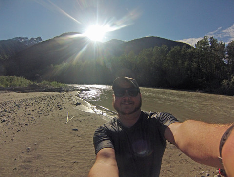
Waking up at the Dyea (Die-ee) Campground, I mull over my plans for the day. I’ve got a day to burn before starting my hike. Eventually I decide to head back into town in the morning to see the last couple corners of town as well as a few chores. Finding the best spot for WiFi for the digital chores takes a bit of schmoozing with a few locals, but eventually they yield the info. A few hours spent sifting photos/vids and I move onto the park service to snag my permit for tomorrow.
They require a bit of info be filled out and an orientation be done and bear safety briefing be listened to. They do them a few times a day. The paperwork required seems a bit more than typical, but I'm reminded this hike (and park housing it) is jointly managed by US and Canada. Mentally marking a time to return for the orientation, I leave without my permit and move along to the gear shop in town for a couple small things, as well as the hardware store. I talk to a few important people back "home" and use the remaining 45 minutes or so before the next briefing to sample the local brewery's offerings.

--- Homeless again. Not the first time, and not likely to be the last.----
The orientation is more or less common sense stuff, but there's a bit of trail and train specifics that are useful. The bear information is also review, but seeing bear spray in action, on grizz and how quickly they react and run is psychologically comforting. The other two groups starting the same day as me are taking five days to do this... I'm doing three and thinking its too much. Wondering who's planning is more suspect, I leave permit in hand this time.
At my gear shop and park service stops I did a little mining for information on floating the Taiya river, but each person only has a piece to the puzzle. But, having talked to so many with little bits of info, I think I've gathered enough for the run. Now is the time!
I head back up to camp and throw the requisite gear into my smaller pack, as my larger pack is partially packed for the Chilkoot already. before heading out, I walk to the riverbank to take a mental picture of what my endpoint looks like, then I go a step further and plop down a GPS waypoint on my inReach. Luckily, there is a bridge at the Chilkoot trailhead about a half mile up the same road that camp is on. It will serve me nicely as a landmark to peel the eyes for my take out spot.

I seem packed, so I hoist the bag, complete with broken down paddle sticking way up one side like an antenna. It likes to reach out for low hanging branches, but luckily there aren't too many on the first 5 miles of trail up to Finnegan's point. The path more or less follows the river and doesn't include too many ups and downs, so I progress pretty quickly through the bright forest. I only bump into one group of other hikers, which turn out to be a guided tourist group. Chatting with the guide a bit, I learn more of the river conditions as well as that his buddies ran the river in packrafts from about the same point I'm planning not too long ago when the river was flooding. Evidently it created some decent class three rapids that bucked one guy from his boat. They actually assumed they lost the boat but came back the next day and found it caught in an eddy unharmed. He detailed two portages that they had to do and told me of a place I can likely see one of them.

As i continue down the trail, my eyes are to my left, on the river. I'm looking for dangerous blow downs crossing the water that I need to either avoid on the water or walk around. Unfortunately, on checking my map I realize the water I can see is mainly a smaller side channel and not the one I plan on running. I keep looking for the spot my new guide friend mentioned to at least get eyes on one of the dangerous spots. Eventually I get to it, but the view of the river isn't quite as useful as he made it seem. I can imagine (and almost see) that just at the upstream bend from where I stand is the logjam he mentioned, so I tag that on my GPS as well.
In the final mile to Finnegan's point, another mosquito flies just into my vision. Honestly, they haven't been too bad today, but my killer instincts have been honed to reach out and perform a one handed grab-n-squish whenever the little bastards stray too near me. This one turns out to be a bee. Before I've really made the discovery in my head, my hand has recognized what it has grabbed is startlingly substantial compared to the tiny mosi's it's used to and lets go. Thank goodness. He buzzes off more confused than angry. Dodged a bullet there.

Once at Finnegan's, the first camp on the Chilkoot, I easily cross the small channel to a central island abutting the main channel to build my boat. The surrounding view is just breathtaking. The far peaks are snow covered and wreathed in drifting fog. There is a large, long, cascading waterfall in one of the cracks along one of the nearer, greener mountains. It likely feeds my river actually. Lucky to be alive and in this moment, I inflate and assemble the boat and lash my now nearly empty pack onto the front deck. A little nervous for whats to come, I push off.


The water is colder than I anticipated. This discovery make me wish i'd brought splash gear for a bit more protection from it. If i swim, its going to be quite cold. Borderline dangerously cold, but thanks to this being the day before summer solstice, I've got plenty of sunlight to warm up in if the worst happens. Not 5 minutes after that thought, the sun drops behind the canyon wall. Ha!
Suddenly it feels soft. The boats 'rubber' is not taught. Pushing on it with my hands, it yields far too much. Crap! I've got a leak I couldn't hear on shore. And it must be a pretty big one to loose this much air this quickly! I pull over to the bank and hop out. Listening for the telltale hiss of escaping air and looking for bubbles, I'm puzzled. the valve is screwed in tightly, no leak there either. Its the cold water! I forgot about its effect on inflatables. The gas laws I learned so well in school come flooding back to me. I top off the boat once more and the pressure holds the rest of the trip. Whew.


The scenery continues to amaze, and a bald eagle parched on an island casually watches me paddle by. the river is a bit of a slalom of blow down trees, but its runable. I end up having to do one short portage around the logjam the guide described, almost exactly where my waypoint said it'd be. There are no real rapids to speak of, which i'm thankful for without my splash gear. Its a bit more relaxing than exciting, but that's more or less what I was expecting. Such a visually exciting ride to cool off from my hike. Its cold enough that the warm wind blowing in from the sunny areas is a welcome treat. The sun graced me with its return about halfway down as well, keeping me comfortably warm.
Passing under my bridge turned landmark, I start looking river left for my camp's little beach. I find it and pull over to it. The river is still swift here and there is no eddy. I try to grip the land with my left hand, setting my paddle on the shelf of dirt. the current grabs the boat and pulls. I'm forced to make a beached whale kind of ungraceful boat exit/flop onto land, holding the boat in place with my right foot. Calamity averted I drag the boat safely onto land, laughing out loud at myself. Success! I'm a little cold, more than a little wet but thoroughly satisfied and smiling. Today was a good day. My soggy walk back to my van is a glorious one. A drippy victory lap.
Comments